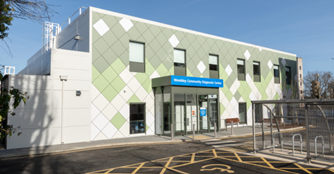
Find Wembley Community Diagnostic Centre
Plan your journey to the Willesden Community Diagnostic Centre
Use the information and tools below or visit the Transport for London website to plan your journey to the Wembley Community Diagnostic Centre.

The Wembley Community Diagnostic Centre is the green building at the back of the site.
If you are walking, please follow the green line up to the centre. If you are driving, parking is available to the right of the centre, through the gates. Two disabled parking bays are available outside the entrance.


Wembley Community Diagnostic Centre
116 Chaplin Road
Wembley
London
HA0 4UZ
Main contact number
020 370 48540
Travel options
Underground and Overground
Bakerloo and Overground
Wembley Central (15 minute walk) Wembley Central, High Rd, Wembley HA0 4AP to Wembley Centre for Health and Care - Google Maps
Departures - Live Departure Boards - Wembley Central - National Rail Enquiries
Arrivals - Live Departure Boards - Wembley Central - National Rail Enquiries
Piccadilly
Sudbury Town (13 minute walk) Sudbury Town, Station Approach, Wembley to Wembley Centre for Health and Care - Google Maps
National Rail
Sudbury and Harrow Road Rail Station (14 minute walk) Sudbury & Harrow Road, Wembley HA0 2LW to Wembley Centre for Health and Care - Google Maps
Departures - Live Departure Boards - Sudbury & Harrow Road - National Rail Enquiries
Arrivals - Live Departure Boards - Sudbury & Harrow Road - National Rail Enquiries
Bus
Please use the Transport for London bus map to help you find your way to our hospital. The following buses stop near the hospital:
|
Bus number |
Bus route |
Map and timetable |
|
H17 |
Harrow to Wembley |
|
|
18 |
Sudbury and Harrow Road to Euston |
|
|
83 |
Golders Green to Alperton Station - Transport for London (tfl.gov.uk) |
|
|
92 |
Ealing Hospital to IKEA Brent |
|
|
182 |
Bannister Playing Fields to Brent Cross Shopping Centre |
|
|
204 |
Sudbury Town Station to Edgware Station |
|
|
297 |
Pound Lane/Willesden Bus Garage to Ealing Broadway Station / Haven Green |
About this page
- Last updated
